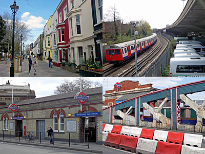
HAMMERSMITH & CITY: Walk the line 125 years before the Hammersmith & City line there was the Hammersmith & City Railway. Opened in 1864, it was built as an offshoot of the Great Western Railway to carry passengers from Paddington to Hammersmith. The new tracks left the GWR mainline at Westbourne Park and ran on a curving viaduct through mostly undeveloped fields. At Latimer Road the line split, one branch to Hammersmith, the other to Kensington. The latter branch is now part of the Overground, while the former remains the Hammersmith & City. I thought I'd walk it, following a four mile arc alongside the viaduct.[map]
There are two Hammersmith stations, as every local knows, but which still comes as a surprise to visitors attempting what appears a simple interchange on the tube map. Instead there's a busy gyratory to cross, on one side a modern shopping mall, on the other the H&C station. This is a fine Edwardian edifice, a symmetrical structure with pedimented gable end, mostly unencumbered by modernity. Only the far right entrance is used these days, while Alexander's barbershop soldiers on in the central retail space. Something much less memorable is going up alongside, an eight-storey glass block called 10 Hammersmith Grove, into which developers would simply lurrve your business to relocate. Just not yet, because it's a right mess at ground level while builders complete the concrete piazza outside. Beyond the gym and training centre the rest of Hammersmith Grove is much more desirably residential. Most of the streets ahead are similarly blessed, lined by tall terraced houses with white bay windows and fortunate tenants. Only when a road slips off to the right is the reality behind revealed, with a builders yard and a secure facility lodged up against the railway.
Trussley Road provides a rare crossing beneath the viaduct, but the sight of businesses in the arches will become more familiar as the walk progresses. Shoots and Leaves is one of the more upmarket outlets - they do landscape design and garden maintenance - with neighbours involved in bathrooms suites and paint. Sulgrave Road is currently a riot of pink cherry blossom, most appropriate on a Hammersmith & City line walk, but alas only a temporary signposting system. An unexpected sight is the back of a busgarage, accessed on foot up a "no public access" alleyway which all the local public seem to use. This emerges into the heart of the machine, where terminating buses turn into the front of the depot and where the drivers park their cars under the viaduct. It's no safe place to be, hence no footpath, but it is the perfect shortcut to the shops. [Here be Goldhawk Road]
Goldhawk Road has loads of shops, surviving as best they can in the shadow of Westfield and under imminentthreat from developers. There are some ace survivors, including several eateries dating back to the glory days of the 60s. The Zippy Diner has a Wimpyesque interior, rarely preserved, nextdoor to the darker Rostomia cafe/restaurant. Further down is a pie and mash outpost, courtesy of ACooke's, where a QPR 2010/11 Champions banner hangs well past its sell by date above the tables. I ventured inside Vivian Patisserie, a Chinese Food Bakery where cheap sweet treats are laid out and inventively labelled. A 'Lemond Tart' appealed, but instead I plumped for a large juicy 'Raisimg Danish', a sub-£1 snack that put corporate coffeeshop fare to shame.
For further bargains, try the market. Shepherd's Bush Market runs along the edge of the railway viaduct, all the way from one station to the next. This characterful multi-ethnic bazaar is the place to come for shoes, foam, unlocked phones and halal cuts... but not on a Sunday. On a Sunday the arched entrances are shuttered shut and the usual retail cut-through is unavailable, so you'll have to make do with some words I blogged 18 months ago. Instead the shortest route north is via Lime Grove, past where the BBC studios used to be but where there are now bland flats. The rest of the road maintains smart residential decorum, or so you'd think by the looks of it, but the sight of two late-middle-aged ladies in hoodies squabbling over a recently-purchased aerosol of glue told me otherwise. [Here be Shepherd's Bush Market]
The Uxbridge Road has a more Middle Eastern flavour, ideal if you need a jilbaab or Damascene cuisine. It's also not the place to dash across the street without looking, as I deduced from the ambulance staff tending to a prone body in the middle of the road beside a knocked down suitcase. I crossed more safely, lest the rubberneckers turn their steady gaze on me instead. The bustle of Shepherd's Bush Green can be avoided by turning left at the Bush Theatre to follow MacFarlane Road. This is another desirable residential street, right up to Auntie's massive satellitedishes hanging over the railway viaduct at the end of the road. Here you'll find the back entrance to BBC Television Centre, the direct route to the rear of the scenery block, now deceased. When this end of the site is redeveloped for flats, expect renewed interest. [Here be Wood Lane]
Redevelopment has already transformed the next part of the walk. You'll know it as Westfield, rather than the Central LineRailway Generating Station and Depot. No shops stretch up here by the pink railway bridge, instead there's an unexpectedly underused bus station and an expanse of warehouses. One of these belches out multi-coloured Ocado lorries on a regular basis, so best cross the entrance with care. To avoid the crowds follow the broad pavement along Ariel Way, where no shopper has any need to go, and where of course a large hire bike docking station has been installed. Planners kindly installed a pedestrian footbridge over the Overground when the megamall complex opened, allowing the estatefolk beyond to avoid a long detour. It's cut my H&C walk by half a mile too, for which I am forever grateful.
North Kensington's a peculiar place. Some of it, like Notting Hill, is upmarket like nowhere else in London. Other parts are rather less so, for which we can partly blame transport links. First the Hammersmith & City viaduct divided the land in two, then a century later two motorway-standarddual carriageways scythed through the streets. To see the nicer houses, stay well away from the railway. However, that's precisely where this walk is heading. The Hammersmith & City line rattles across the main road between a forest of warehouses and commercial blocks. The inhabitants advertise themselves in big branded letters on the top floor - Monsoon, Accessorize, Talk Talk. Even Heart FM are based here, firing up the playlist computer from a gated development erupting from a former brewery. A least someone on Bramley Street has a sense of humour - a mixed-use block near the railway is called Pippin House. [Here be Latimer Road]
Latimer Road no longer runs as far as the station of the same name. Instead it's been amputated by the A40, with the area around the station now stacked full of flats and low-rise modernity. As kids ride their bikes up onto the pavement past Costcutter, it's hard to imagine that David Cameron's house (pre number 10) is only a few hundred yards ahead. We'll not go there. It used to be possible to take a shortcut along Station Walk by following an alleyway immediately alongside the viaduct, but that's been temporarily blocked while a new academy is built. So great has the pace of change been around here that a Methodist church spire marks the only readily visible sign of pre-war construction.
It's around here that the Hammersmith & City line nudges up against the Westway, although chronologically speaking it was the other way around. Why destroy new areas with a road on stilts, argued the planners, when you could simply eradicate the row of houses closest to the railway line. Local people have made the best of this concrete intruder by installing a range of businesses and services underneath. North Kensington's ambulance station is located here, as is the Westway Sports Centre and the occasional plumbers' merchant. At St Mark's Road the space is filled by a forlorn looking lightpole sculpture, apparently temporary, but the weatherbeaten state of the floor covering suggests otherwise. [Here be Ladbroke Grove]
Sainsburys have filled the void beneath the roadway at Ladbroke Grove, with trains running across a brightly coloured bridge alongside. Metronet helped to provide this vinyl disguise, as well as two vibrant Bridget Rileyesque panels at street level on either side of the span. The space ahead is used for overspill to Portobello Market, and has such edgy graffiti that one couple on Sunday had brought along their lemon yellow 1970s car for a photoshoot. The under-road spaces here are occupied more commercially, including a dark uninviting arcade of boutiques, plus a cavernous live music and arts space called Flyover. Only a handful of stalls spread out their wares on the second day of the weekend, but there's just enough crafty-stuff and collector-bits to make a Sunday visit not quite utterly wasted.
To escape the hubbub, and for the longer walk to a station, head east up Tavistock Road. Outdoor cafe culture soon subsides, past one last tweely-painted row of terraces. At a triangular open space the road divides, providing a rare public oasis for slouching and rocking on swings. Tavistock Crescent has clearly been rebuilt as a residential sound barrier, its brick façade blocking out the noise of the Westway for the benefit of those living in the proper houses to the south. Only one gap exists, to allow St Luke's Road to continue across the railway, but not for cars, which is why the roads are so quiet. [Here be Westboune Park]
Alongside Westbourne Park station is a pub called The Metropolitan, which sounds wrong, but up until 1990 that was indeed the underground line which served here. The bridge marks the point where the H&C meets the Great Western Railway, with the station's ticket hall straddling the mainline. From here onwards Brunel's chasm divides the landscape in a not especially attractive way, which is why Westminster council built the Brunel Estate alongside and rehoused people there. And then suddenly comes a dash of wealth. I was taken aback by the crowds drinking outside The Westbourne, and the achingly hip kids popping into the Idler Academy for books and espresso. I shouldn't have been - the avenues to the south are home to the well-to-do of Bayswater, and I'd merely approached from the wrong direction.
A long stout brick wall shields the northern side of Westbourne Park Villas. There are only two ways across the railway, one a lonely-looking metal footway, the other a characterful pink/green-painted iron span for vehicular traffic. LordHill'sBridge looks much the worse for wear, with plastic barriers down the middle of the road to prevent overloading, and segregated pedestrian walkways. The ironwork blocks sight of the entrance to Royal Oak - surely the underground station whose name least matches up to the reality of its situation. Crossrail are busy digging the Royal Oak Portal beneath, their mammoth works clearly visible from the island platform. A modern railway will soon descend beside the old, but only the H&C can whisk you from here to Paddington. [Here be Royal Oak]
HAMMERSMITH & CITY: the West end Having walked from Hammersmith to Royal Oak, how about riding it? There are eight stations in total, each a bit different, but still very much of a type. Here are a few notes on each, plus two photos. Feel free to add your own thoughts in the comments boxes, and I'll add the most interesting later.
Hammersmith
• Designed by the Great Western Railway Chief Architect P.E. Culverhouse, and opened in 1909.
• The prow-ended central ticket office was removed as part of an upgrade in 2010.
• The Next train indicator by the entrance tells you which platform to head to, but not how long before the train goes ("oh damn, it's just left, I'll have to walk back to the entrance to see which train's leaving next") [exterior][interior]comments
Goldhawk Road
• Entrance is via one of the arches in the viaduct, in an entirely non-attractive way.
• The platforms have been extended to take longer trains, then bits of them painted a non-attractive shade of yellow.
• There are no Next Train Indicators anywhere between here and Royal Oak. Please listen for announcements. [exterior][interior]comments
Shepherd's Bush Market
• Used to be called Shepherd's Bush, except there were two of them, so TfL grasped the opportunity of an imminent Circle line extension to rename the station - something usually deemed too impractical and expensive.
• The stairs are narrow and really steep, and therefore entirely buggy-unfriendly.
• Goldhawk Road could also have been called Shepherd's Bush Market, because the market runs between the two stations. [exterior][interior]comments
Wood Lane
• Opened in 2008 to serve Westfield, so all silvery-glassy modern.
• Deliberately built without a ticket office, to save TfL the bother of closing it later.
• There's an old-style roundel in mosaic, massive size, at the end of the passageway through the arch. It was salvaged from the surface building of the old Wood Lane station on the Central line. [exterior][interior]comments
Latimer Road
• Yet another station entered via an arch in a viaduct up steps to reach a long facing platform with an extended bit at the end.
• This time the extended bits have a lot of brown on them. It's not much nicer than the yellow.
• The platform canopies look quite arson-friendly. Please don't check this, obviously. [exterior][interior]comments
Ladbroke Grove
• It's "Ladbroke Grove (for Portobello Road)" on the roundels on the platforms.
• The eastbound platform has an 'Information and assistance' window, from which staff make "next train" announcements that are broadcast all down this end of the line.
• Even 23 years after the line was rebranded, the handrails in the stairwells are still painted Metropolitan purple. [exterior][interior]comments
Westbourne Park
• After a run of viaduct-level stations, this one's back at ground-ish level.
• Has a special side entrance wide enough for ten-abreast entry, round the back of The Metropolitan pub, for use solely during Notting Hill Carnival chucking out time.
• Beyond this station the H&C dives under the Great Western mainline and emerges on the other side. [exterior][interior]comments
Royal Oak
• A permanent sign out the front points the way to the Notting Hill Carnival (and to Bayswater, and to Warwick Avenue).
• The station has a "Community Board" in the entranceway off the bridge. The paucity of notices on the board suggests there's not much of a community round here.
• The island platform, in a chasm with mainline trains rushing by, is a lonely place. [exterior][interior]comments
Friday, March 01, 2013
CENTRAL: Ten line facts
• When it opened in July 1900, the line was known as the Central London Railway. The line was soon nicknamed the "Twopenny Tube" because it charged a flat fare. Only on 23 August 1937 did the current Central Line name come into use.
• The Central is London's longest underground line, with 46 miles of track. It also boasts the longest possible journey on the network - 34 miles from West Ruislip to Epping.
• The line was opened by The Prince of Wales (soon to be Edward VII) who made an eighteen minute non-stop journey from Bank to Shepherds Bush.
• The lifts at all the original stations have been replaced by escalators, except at Holland Park, Queensway and Lancaster Gate.
• Central line trains are now 20 years old. Each is 132.3m long, and its eight carriages contain a total of 272 seats.
• The western end of the Central line originally terminated at Shepherd's Bush. Tracks were extended to Wood Lane in 1908, Ealing Broadway in 1920, Greenford in 1947 and West Ruislip in 1948.
• The eastern end of the Central line originally terminated at Bank. Services were extended to Liverpool Street in 1912, Stratford in 1946, Woodford and Hainault in 1947, round the Hainault loop in 1948, Epping in 1949 and Ongar in 1957. The EppingtoOngar shuttle closed in 1994.
• During World War Two, before the eastbound extension of the line opened, an aircraft-componentfactory operated in the twin tunnels between Leytonstone and Gants Hill. It was 2½ miles long.
• The Central line's official colour is Pantone 485
• The Central line has a split of services that you may not have noticed. West Ruislip trains go up the Epping branch, and Ealing Broadway trains go round the Hainault loop. Generally speaking. [full line history here]
CENTRAL: Down the line
Every month this year (with the exception of January), I'm focusing on one of London Underground's underground lines. Last month I kicked off with the Bakerloo line, and this month I've decided to move on to the Central. I know it looks like I'm working through in alphabetical order, but that's just a coincidence, honest. Expect a March filled with various Central-related posts, here and there, every now and then, on diverse topics. As before I'm introducing things with a ride along the line, this the Underground's record-breaking longest possible journey. I've always wanted to do that...
It's 34 miles from West Ruislip to Epping, a journey scheduled for completion in an hour and twenty-five minutes. Normally only the driver goes from one end to the other, but I thought I'd join him, from the heart of Hillingdon to the edge of Essex. The journey kicks off in bright sunlight, although that doesn't stop some muppet in the West Ruislip control room pressing the "In these adverse weather conditions please take extra care..." button for an unnecessary tannoy announcement. Trains head off to Epping every six minutes from either side of the island platform, so pick carefully, and let's start the stopwatch.
To start with I have the entire carriage to myself. It won't last, as our journey through the metropolis rises to a midtown crescendo then fades away into the suburbs. In less than a minute we've passed over the Metropolitan line (a lost linkage opportunity?) then alongside a large Central line depot (where the Vickers Aquamatic washes trains). Ruislip Gardens isn't as green as its name might suggest, more the name of the housing estate to one side. My first fellow passenger is a coffee-clutching smartphone user with a ponytail, though very definitely not the Shoreditch type. At South Ruislip a silver Chiltern train rushes by without stopping, because these outer interchanges aren't important to long distance travellers. One day HS2 will pass this way too, running to the north along parallel tracks, but not if the angry residents of Northolt etc get their way. The Central line runs intermittently in elevated section, offering a mixture of rooftops, treetops and warehouse roofs. The view has improved considerably by Greenford, from whose raised platforms spires and hilltops can be seen amid the entire expanse of west London.
By Perivale there are five of us in the carriage, two jabbering away "yeah yeah yeah" about the cost of pay as you go. It may be mid-afternoon but, out here in Zone 4, passengers are having to make do with reading a Metro because the Evening Standard is for inner Londoners only. Housing slowly makes way for business and industry as we descend into the secluded heart of the Hanger Lane roundabout. We cross the Piccadilly line for the second time, skirting the Park Royal trading estate, before joining up with the Ealing Broadway branch of the Central at North Acton. A pig-ugly Holiday Inn peers down from the embankment above, adjacent to several other brown buildings designed by the same school of sadistic architects. By contrast the housing estate at East Acton has the finest chimneypots along the entire route, and even Wormwood Scrubs scrubs up well, its variegated gables seasonally visible through a screen of leafless branches.
The tracks swap sides (via an underpass) so that trains roll into White City on the right, then swap back again shortly after departure. We've dipped below ground now, where we'll stay until Stratford. Somewhere in the darkness is the site of the old WoodLane station, built on an inconvenient loop, and ahead is the sharpest curve on the entire underground network, but only for those travelling in the opposite direction. Westfield shoppers board in number at Shepherd's Bush, joining BBC types from the previous station, and it's starting to feel busy on board. One particularly wide bloke is taking up 1½ seats, while a narrow chap takes up two by resting his trainers on the moquette opposite. Holland Park and Notting Hill Gate are a little gloomy, the latter station frequented by unexpectedly stereotypical blondes who flounce aboard and natter.
A late arrival on the platform at Queensway manages to dash aboard between the closing doors without quite looking foolish. Then at Lancaster Gate two passengers deliberately allow our train to depart, intent on waiting for a Hainault service, not our Epping. We get our first "standers" at Marble Arch, the first boarders to ignore spare seats in favour of hanging around by the doors. And that's just an omen of what's to come at Bond Street, where central London hits big time. In they pour, one shovelling a Quarter Pounder inelegantly into his mouth, another lady finally taking the plunge and squeezing into the half seat beside the Three Hundred Pounder.
We've been running for nearly forty minutes and are now about halfway through our journey - currently rumbling beneath the retail turmoil of Oxford Street. Oxford Circus is the first station at which more people get out of our carriage than get on, but that's only because the horde of waiting shoppers have refused to spread out down the platform. At Tottenham Court Road a lady drags her small red suitcase over my feet "sorry" and plonks awkwardly "sorry" into the seat beside me "sorry". I'm voting Holborn the most crowded station en route, the first place where someone has to wander down and stand between the two rows of seats. Things could be much worse though - a couple of hours later people will be standing in vain on the platforms at Chancery Lane and St Paul's unable to squeeze aboard.
I'm expecting the brakes to screech as we round the sharp curve at Bank, but they don't. Instead a few financiers hop across the gap and ride one stop to Liverpool Street for their mainline train home. This is where the overcrowding situation in the carriage finally eases, with everyone now allocated a seat or at least their own place to lean. Those who remain on board are the true East Londoners - the skateboarder holder, the phone clicker and the headphone nodder - on the long run through to Bethnal Green. We stop. The doors open. "Ladies and gentlemen, please stand behind the yellow line as the train approaches" announces a disembodied voice, synchronised by some unseen idiot.
The cross-platform interchange at Mile End works like a dream for those who need the District line, on this occasion more by accident than operational design. Red Suitcase Lady stands as soon as we depart the station because she wants to alight at Stratford, but doesn't realise that's three minutes away and soon regrets her premature decision. At last we emerge into the sunlight, after ten miles underground from one Westfield megamall to another. And at last there are seats again, two of which are nabbed by a Rizla roller and a probable alcoholic. Leyton marks a full hour since we started out, and the first occasion we've been travelling fast enough for the train to rattle.
We shadow the A12 arterial to Leytonstone, where the line splits, and we're taking the overground route. Suddenly trackside looks properly suburban again, as do the stations. Snaresbrook has cute ironwork, and a cafe on the southbound that dispenses caffeine to early morning commuters, while South Woodford used to boast "The Railway Coffee Tavern" but no longer. It's school chucking-out time by the time we reach Woodford. A gaggle of girls hide away in the waiting room to gossip, while a lone boy boards the train, flips open a lime green iPad and downs a can of generic energy drink.
There are just ten passengers in the carriage as we cross into Essex, following a line of commuter settlements up the Roding Valley. Thin tongues of garden back down to the railway from neat rows of semis, interrupted at Buckhurst Hill by a very British Rail style station. By contrast Loughton has a splash of architecturalbrilliance that looks much more London Underground, its platforms dominated by "kidney-shaped flat-slab canopies" and "pairs of freestanding lamp-standards". After Debden it becomes clear we've finally left the metropolis behind, as schools and houses make way for fields and flowering gorse. Now only single cottages dot the countryside, and Theydon Bois feels more like a rural halt.
Ahead can be seen traffic on the M25, with streams of lorries rumbling ever closer until we pass underneath. And that's almost it, nearly an hour and a half after our journey began, because the town ahead is Epping where this train terminates. We pull into the left-hand platform by the ticket hall, and most of the remaining passengers head off to the adjacent oversized car park. The line to Ongar stretches deceptively ahead, unused now for almost twenty years because Transport for London has no desire to serve a minor Essex backwater. The driver emerges from his cab and wanders back down the train, which in six minutes time will become another record-breakingly long return journey to West Ruislip. Whilst this line may be called the Central, its outer extremities are truly anything but.
CENTRAL: End of the line
Five tube stations have the word Ruislip in their name, but only one marks the end of a line. That's West Ruislip, way out in zone 6, where Central line trains from Epping terminate. In case you've never been, I have, and here's what I can tell you about the place.
1) The station
There are nicer stations than WestRuislip, but there are far worse. Central line trains run either side of an island platform with a central canopy, and departing passengers need to check the signs carefully before boarding. The peculiarity here, shared with South Ruislip down the line, is that Chiltern trains have separate platforms alongside. They don't stop that regularly, not outside peak times, but it's nice to have the opportunity to travel further. We'll come back to this. The front of the station has a broad façade with a gently bending porch beneath a lantern roof. It could easily be something TfL had designed, except this place was built by British Rail in the 1960s. Immediately to the right of the entrance are your usual food stores and takeaway, but to the left is a minor police station, which suggests this area is a hotbed of crime. It doesn't look it. Immediately opposite the station is a golf course, and a Harvester-style restaurant which runs comedy nights and slimming classes to pack 'em in. We're right on the border between Ruislip and Ickenham, which is why this station used to be called Ruislip & Ickenham, then West Ruislip (for Ickenham) before losing the Icky bit. A lot of fresh flats are being built just down the road at Ickenham Park, on the site of what until fairly recently was RAFWest Ruislip. But mostly what's down the road is Metroland, and a very pleasant corner of Metroland too.
2) The extension West Ruislip wasn't scheduled to be the end of the Central line. When the western extension was mapped out in the 1930s the line was due to go further, all the way to Denham in Buckinghamshire. But the war came along and interrupted things (which is one of the most overused phrases on this blog) and the original plans had to be curtailed. The problem was the golf course across the road from West Ruislip station, and all the undeveloped land beyond it. After World War 2 this became part of the Green Belt, which meant no houses could be built beyond, and without houses there was no point in continuing the railway. If you look over the side of the bridge opposite the station you can see where thedream ended. Two dead end sidings terminate at a pair of unconvincing looking buffers, while a single track links up to the Chiltern line beyond. The Central line could have been the only tube line to exit Greater London twice, but it wasn't to be.
3) The missing station Denham station already existed when the Central line extension was killed off, but one intermediate station never materialised. That would have been Harefield Road, a halt approximately halfway along the unbuilt section, shortly before the Chiltern railway crosses the Colne Valley. What a fantastically remote and unlikely spot for a station this is. A lonely bend in a minor road, surrounded by fields and woodland, and not a house in sight. The only folk living within half a mile are farmers. There is one other business here, that's Uxbridge Skip Hire, who run their operations down a bleak track which goes by the name of Skip Lane. Public access is along a pavement from nowhere, or the U9 bus runs through - Hail and Ride only. As for the town of Harefield itself, that's two miles away, and an absolutely 'no' to walk to after dark. There is no conceivable economic justification for a station in this location, indeed there's an air of Blake Hall about the place, for those who remember the pointless platform at the Ongar end of the line. But that's the point. Harefield Road station was meant to generate development, not to serve it. Had the Central line extended, these fields off Harvil Road would have been swallowed up by acres of semis and bungalows, and a parade of shops, and a school, and who knows what else besides. Instead the Green Belt has done its job and this place remains mostly unspoilt, at least until HS2 appears and carves a whopping cutting out of the adjacent woodland.
4) The missing link A few hundred yards south of West Ruislip station the Central line passes over the Metropolitan and Piccadilly lines. It doesn't stop, indeed there's no convenient way to change from one to the other. When Tube Challengers come this way they have to run, unless the hourly U10 is passing by, that elusive bus of legend. It would be foolish to add a new interchange station here - West Ruislip is much too close - so the trek to Ickenham or Ruislip remains. But there have been mutterings, even semi-coherent plans, to link the lines together. Hillingdon council would love nothing better than to divert Central line trains away from West Ruislip and off towards Uxbridge. That would bring three different lines into the heart of the town, and offer commuters a greater choice of routes into the city. I'm not convinced that Uxbridge station could cope with the additional trains, and I don't think residents of West Ruislip would be very happy either. But a link wouldn't be as difficult to achieve as many other pie in the sky interchange schemes. The two lines are already joined via a track round the back of Ruislip depot, where large numbers of Central line trains are stabled overnight. It'd take some major reorganisation to create two-way passage, and the carriages full of ballast currently stored up the sidings would need to be shunted elsewhere. London Reconnections discuss the issues here, in some detail. This potential junction is quite hard to see, except from a train, although if you stand on the road bridge at Austin's Lane you can see the dead end buffer where the Central line might one day merge. I wouldn't hold my breath waiting, to be honest. Until which time West Ruislip station will continue to be the end of the line that shouldn't have been the end of the line, imperfect but immovable.
CENTRAL: Out of place
One unusual feature of the Central line is the number of stations named after places elsewhere. Here's why and how.
Holland Park: This station is named after HollandPark, a green expanse that was formerly the grounds of Holland House, which used to be a grand Jacobean mansion until most of it was firebombed during the Blitz, and which had started out in 1604 as Cope Castle, but which was renamed Holland House in 1625 when it was inherited by the Earl of Holland’s wife, that's not Holland across the North Sea, that's Holland one of the three medieval subdivisions of Lincolnshire, the southeastern Part whose main towns are Boston and Spalding. Lancaster Gate: This station is named after an entrance to Kensington Gardens, an entrance which lies adjacent to the Italian Gardens, which were given as a gift by Prince Albert to his beloved Queen Victoria, one of whose titles was Duke of Lancaster, a dukedom first bestowed in 1351, and which survives as Duchy of Lancaster (a portfolio of land and assets held in trust for the sovereign), hence the gate alongside the gardens was named Lancaster Gate in the Queen's honour. Oxford Circus: This station is named after the junction between Oxford Street and Regent Street, the latter street created by John Nash for the Prince Regent in the 1820s, with Oxford Circus created as a roundabout on Oxford Street, which used to be called Tyburn Road because it led to the gallows at Tyburn, and was renamed in the late 18th century, not because the road goes to Oxford but because the surrounding fields were bought up by the Earl of Oxford, not one of the original earls dating back to 1142, but a dormant peerage revived for the statesman Robert Harley. Tottenham Court Road: This station is named after the road leading north to Tottenham Court, which was the manor-house of the Manor of Tottenham, first owned by William de Tottenhall during the reign of Henry III, later an Elizabethan mansion of three storeys with two wings which stood in 1½ acres within a moat, patched up several times over the succeeding centuries until it was eventually demolished in 1808, located not in Tottenham as you might expect, but on what is nowthe corner of Hampstead Road and Euston Road, opposite University College Hospital, roughly where the northern entrance to Euston Square tube station is, which might instead have been named Tottenham Court. Liverpool Street: This station is named after a minor street alongside the mainline station, a street named after Lord Liverpool, the UK's third longest-serving Prime Minister (1812-1827), whose father appears to have been awarded the title for no geographical reason whatsoever. Newbury Park: The station is named after an extensive interwar housingestate, itself named after Newbury, one of the 24 demesnes of Barking, a manorial division of land originally owned by Barking Abbey, back in the days when BarkingAbbey was really important, the name 'Newbury' being first recorded in 1321 and nothing at all to do with the town in Berkshire.
CENTRAL: Line up
There are a lot of escalators on the Central line. They weren't there when it opened, there were stairs and lifts. But now there are almost twenty stations with diagonal-shifting people-movers. And some of them are record-breaking.
Greenford Greenford is well known for having the only escalator on the Underground that you ride up from the ticket hall to reach the platforms. The Central line runs through on a viaduct, just high enough above street level that having to take the stairs would be a pain. The escalator is 30 foot high, that's 9.14m in metric. And there's only one. The down escalator was converted to a staircase a while back, making two hard ways down and only one easy way up. Greenford station was scheduled to be step-free by now, but funding issues caused TfL to pull the plug in 2009 when work on a lift was only part-completed. Preparatory cable and drainage work remains, but only after £2.9m had been spent preparing a lift shaft that'll never be used. It would have been the Central line's only step-free station west of Stratford, but there's Mayoral priorities for you. Instead there's just the one escalator, rolling ever upwards, to reach the platforms.
Even more special, it's a wooden escalator. You don't get these anywhere else on the tube, not any more. Escalators with timber surfaces were phased out after the King's Cross fire for being a combustible risk, but Greenford'shas survived because it's not underground. It's quite evocative going for a ride, for those of us who remember these wooden workhorses all across the network. Chunky treads ascend, all threaded together, with convenient grooves into which to drop a scrunched up ticket or a cigarette paper. You suspect it wouldn't be quite so dangerous to catch a stray shoelace here as it would be on a modern metal chewer, but best not stop to find out. Once at the top it's almost tempting to walk back down the stairs, turn round and glide back up for another go. But best not. The platforms up here are fascinating too. Crammed between the two Central line platforms is a single-track FGW terminus, from which you can ride (occasionally) on one of the least used rail lines in London. I will do that one day and write about it, honest.
Chancery Lane Chancery Lane is well known for having the shortest escalator on the Underground. There are some pretty short escalators elsewhere, like a 6.46m climber at Canning Town, and a 6.31m riser at Heathrow 123, and three 5.60m at West Ham. But Chancery Lane's escalator is piddly, a mere 4.57m, that's fifteen feet in old money. If you choose to take the stairs instead, and you can because a staircase runs up the middle between the pair of escalators, there are only 25 steps. Twenty-five steps is nothing, unless you're elderly, or have a pushchair or a suitcase, in which case whoever installed this mini people-mover is a god. However record-breakingly short it is.
If you're thinking hang on, aren't the escalators at Chancery Lane quite long, that's because there are two sets. One rolls down from the ticket hall, and that's 50 foot long, which is proper big. That takes you down as far as the landing alongside the eastbound platform, which is where half the station's passengers need to go. But a peculiarity of the Central line means the westbound platform is stacked underneath the eastbound, hence the need for the tiny escalator to take everyone else a little further down. Even more peculiarly, the situation one stop down the line at St Paul's is reversed. There the eastbound platform sits underneath the westbound, don't ask me how, but somehow the tunnels swap elevations somewhere under Holborn Viaduct. But the lower escalator at St Paul's is eighteen foot high, that's 92cm more than at Chancery Lane, so Chancery Lane takes the crown.
Stratford
Except Chancery Lane doesn't have the shortest escalator on the Underground any more. That honour belongs to Stratford station, again on the Central line, as of September 2010. That's when platform 3a opened, to ease congestion before the Olympic by allowing doors to open on both sides on westbound trains. It also made it possible to access the central line direct from the main ticket hall, via an existing escalator. And that was a very short escalator, at only 4.1m, which is half a metre less than at Chancery Lane. You have to be fairly lazy to want to ride this one instead of walk up the staircase alongside, but people are lazy, and the escalator thrives.
And Greenford no longer has the only escalator on the Underground that you ride up to reach the platforms. Stratford has one too, the same escalator that trounced Chancery Lane in the shortness stakes. What a shame it's such a dullard. Stratford's record-breaker isn't even a proper Underground installation, more an incidental people-mover in the general vicinity of a shopping centre. But the Central Line still punches above its weight in the interesting escalator department. Why not ride one today?
Escalators shorter than 6m 4.1m Stratford: Ticket hall up to Central 4.57m Chancery Lane: Westbound up to eastbound 5.12m Notting Hill Gate: Eastbound up to westbound 5.15m Tottenham Court Road: Up from Northern 5.49m St Paul's: Eastbound up to westbound 5.60m West Ham: Up from Jubilee 5.64m King's Cross: Northern up to Piccadilly 5.76m West Ham: Up from ticket hall 5.88m Canning Town: Jubilee up to DLR 5.99m Westminster: Up from District
CENTRAL: Walking the Hainault Loop
Once you ride past Leytonstone, the Central line links with no other railway line except itself. The Hainault loop is a peripheral peculiarity, poking out into the heart of the borough of Redbridge, and traversed by few other than the borough's residents. The north and east sides of the loop used to be part of the Great Eastern Railway, joined southwards from Newbury Park to Ilford. Then London Transport tunnelled a fresh connection from Leytonstone, opening in 1947, and the Central line's loop was born. It has ten stations altogether, many of them architecturally intriguing, and trains take just over twenty minutes to travel from one end to the next. I thought I'd walk it. I do this so that you don't have to, remember - indeed on this occasion I'd strongly recommend that you don't. From urban sprawl to inner Essex, there are finer strolls. But hang on in there, especially if this corner of London is unknown to you.[map][16 photos]
I thought I'd start from Wanstead. I couldn't face the trek along the A12 from Leytonstone, plus I'd walked that way before as part of the amazing Linked project. Wanstead is an oasis of pleasantness, but only because the dual carriageway has been hidden in a cut and cover tunnel beneath the village green. The station stands in contrast as an outpost of modernity, a clump of rectilinear boxes topped off by a plain concrete tower. Charles Holden designed it, his plans diluted by wartime austerity, but striking all the same. Those seeking class and culture should head north along the High Street, past the George pub and its plaque "In Memory of Ye Cherry Pey". Alas the Central line follows the A12 east, from here all the way to Newbury Park, and that's the weary road I had to tread.
Cars splashed downhill, past sidestreets abruptly chopped mid-terrace when the new road was driven through in the 1990s. I'd picked a rotten day for it. The rain should have been clearing but instead chucked down even heavier, which is not what you want when striding alongside an arterial. I could have hidden beneath the footbridge, one of the few ways across this tarmac divide, but thought I'd better press on because there were still more than ten miles to go. At the foot of the slope the houses ceased, because this is the floodplain of the Roding valley and much better suited to allotments and sports pitches. Ahead the North Circular crosses the Redbridge roundabout on stilts, only a short distance from the foot of the M11. It's not an easy environment for the pedestrian, funnelled through the middle via a twisting footpath, just remote enough that "what if..." thoughts of solitary crime begin to surface. But nah, absolutely fine.
Here's Redbridge station, another Holden classic. Again there's a tower, but this one's Buckinghamshire brick, while lower down's mostly curves rather than straight lines. The exterior is roundeltastic, not just circles on poles but a whole series wrought in iron as part of a fence around the top of the stairwell. It's all a bit Piccadilly line, but differently quirky and not quite so grand. The station was sited on a traffic island beside the roundabout so it could best be served by local buses, augmented these days by long distance coaches pausing to disgorge motorway folk onto the tube.
You can tell that the main road came first because the next stretch is arrow-straight, with acres of semi-style housing off to each side. This is proper interwar ribbon development, with front gardens shamelessly backing onto the A12 rather than curling away in disgust. Almost all are paved, with hardstanding for a couple of cars and very few attempts at horticulture. A word of advice to the householder who's planted a row of artificial flowers and surrounded them by rings of white pebbles - it's not classy, and a blatant fake when spring's late. If you think London's ugliest building is in Archway or Colliers Wood, perhaps you've not seen Wentworth House. Imagine a shoebox balanced on a coffee table, and now strip away everything lovely about your mental image. The ninth floor office suite is currently up for grabs for an annual rent of £34K, but only a visually dysfunctional boss would move their workforce here.
There's very little to Gants Hill station above ground, just what looks like a redbrick scout hut in the middle of a major roundabout. Dip into the subway, signposted by some lovely solid roundels, and the tiling's bright and sunny. But only if you descend the escalator do the true glories of Gants Hill reveal themselves, notably the arched space between the platforms with uplighters reminiscent of the Moscow Underground. If you like worshipping bits of the Underground, make sure you venture out to this Holden temple to pay homage. But alas I wasn't going to the platforms, I had more of Eastern Avenue to walk. Oh joy, more dual carriageway and exhaust fumes, and more terraced semis facing onto the road. Most of those living out here have wheels, and automotive businesses thrive, be that tyremen, repairguys or in-car wi-fi hi-fi fitters. There's also a sizeable Asian population around here, which again you might not be aware of because you've never visited, reflected in the occasional houseproud façade and pillared balcony.
A major road junction ahead looks like it ought to have the next tube station, but that's only a giant JD Sports on the corner. This is Grays Corner, a retail crossroads where the pub is now a McDonalds drivethru, and where the local newsagent is Fags & Mags. Ilford War Memorial Gardens are the only evident heritage hereabouts, a 1922 survivor watched over by the bronze figure of a soldier, overshadowed on both sides by millennial redevelopment that used to be hospitals. Nobody built a Holiday Inn here because there's something to see, more because cheap beds on the edge of town near the tube are always desirable. And Newbury Park is just down the road - the station nothing special, but the bus station, whoa! Oliver Hill's semi-cylindrical copper roof is breathtaking, especially alongside suburban mundanity, and the worthy winner of a Festival of Britain award. A fine place to pause awhile... maybe even the rain'll stop.
CENTRAL: Walking the Hainault Loop
I'm walking the Hainault Loop, a safari through outer northeast London. First I trudged three miles along the southern edge, along the arterial A12, and now I'm following the Central line north as it swings north out of deep tunnel and into the countryside. There will be horses. There will be muddy puddles. There will be further relentless housing estates. And at the end there will be Essex. [map][30 photos]
Enough of Eastern Avenue. The dual carriageway slogs on towards Romford after Newbury Park, but I needed to follow the Central line suddenly north. Oaks Lane sounded promising, a reminder of when everything round here was fields, although in reality rows of semis leading to an unexciting stack of flats. And then the houses on one side stopped, and the vista opened out to reveal fields. Not exciting fields, more flat green expanses of partly grass, but a welcome change of scenery all the same. To the left a footpath crossed the railway heading for an unseen Sainsburys, but I pressed on towards proper rural, up a pitted track (notionally a bridleway) to a clump of buildings surrounded by agricultural detritus. This is Aldborough Hatch Farm, an outpost of the village of Aldborough Hatch across the fields, part-swallowed by suburbia. I would have taken a photo but the owners were standing around outside, and nothing screams "Neighbourhood Watch" louder than a stranger unexpectedly snapping your outbuildings. They drove off in their 4×4 along the lane, dirt splashing as they rolled, past a couple of very damp looking horses.
It's not far, not far at all, to the edge of Fairlop Waters Country Park. This is the dull corner of the park, unless you like golf. A wooden signpost pointed past the lake to Fairlop station, but I followed the shorter finger along the lane towards Barkingside - the briefer non-muddy option. Redbridge council hides a youth offending centre at the tip of Station Road where most won't see it, and here too is Oakside Stadium, home to Barkingside FC. They play in the Essex Senior League and are only eight promotions away from the Premiership, although judging by current form that's looking unlikely. For a decent view of any action try the footbridge at Barkingside station, which is alongside. The station building is Grade II listed, this time not for modern reasons but because it's 1903 classical. Cream stone quoins. Granite plinth. Small domed cupola. That sort of lovely.
Just down the road is Doctor Barnardo'sVillage, this for girls to make up for the fact that before 1876 everything had been for boys. It has 14 cottages set around a rural green, and a children's church, and a Tesco on a patch of land since sold off. But to follow the railway I didn't walk that way, I followed Craven Gardens - suburbanly nondescript to the end and then wow. At Fullwell Cross is my favourite London library, from the outside at least. "A low, circular concrete drum with simple yet varied fenestration, rising above the centre of which is a lantern with arched roof lights and conical - almost tent-like - shell roof with a green copper finish." It could be a crown, or some symmetrical type of hat, but truly it's just circular genius. The architect was Frederick Gibberd, famed for Harlow New Town and for Liverpool Metropolitan Cathedral, and ah yes, there's the similarity. The council have even used a sympathetic sixties font for the big yellow letters facing the high street... they're clearly well read.
Fairlop station is one of the least used on the Underground, because the Central line passes just too far east to be convenient. Back in the 1940s the station was surrounded on all sides by Green Belt, bar a thin strip of housing running down to Fulwell Cross, a not insignificant walk away. The boating lake will never bring major passenger traffic, nor the golf course and garden centre, but the local High School packs them in daily. Look, it has an Amstrad Technology Wing, courtesy of Barkingside's cheery local millionaire Sir Alan Sugar.
Journey to the centre of the Hainault Loop: I thought I'd take a brief diversion at this point to explore the bit in the middle. Where, I wondered, is the unfortunate settlement in the middle of the Hainault Loop, with a dozen stations all around but none close by. And that'd be Clayhall, an expanse of interwar housing estate merging into several more expanses of interwar housing estate, but this one invisible on the tube map. I took the 169 bus up Fullwell Avenue to its terminus at The Glade, which I think is about as far from the Central line as you can get. All ever so residential and not much more, I thought. But a footpath led off between two blocks of flats to an appealing-looking green space, rising beyond on wooded slopes, and topped off by a distant water tower. It looked intriguingly explorable, were it not for the muddy grass and the flooded path, so I thought better of it. Somewhere to revisit in the summer, I think, but for now, the next bus back.
I alighted back at the roundabout by the New Fairlop Oak - which is both a pub and a famous tree. The East End used to decamp to Fairlop on the first Friday in July for a drunken revel beneath the oak's broad branches. 250 years later many of the East End have moved here permanently, as the jolly mannequin outside the halal butchers suggests. St Francis Church up Fencepiece Road has a green pyramidal spire and a very 30s design, as if it were somehow a church hall that grew too far. Alas it's the last vaguely interesting building for a while, because Hainault is more somewhere to live than a location to revel in. Here the residential avenues swamped both sides of the Central line before the Green Belt set solid, so the entire area is now houses and schools and intermittent shopping parades.
Only on the platforms is Hainault station impressive. Down at ground level there's little but a pair of unprepossessing entrances, watched over by a low bridge and a billboard advertising Sky Movies. Meanwhile on the other side of the road is the entrance to Hainault Train Maintenance Depot - a key Central line stopover. It's reached up an avenue of silver birches, plastered with enough 10mph speed limit signs to remind even the most amnesiac driver. And the sidings block the way somewhat for walkers, not that there are many of us attempting to travel up the line on foot, to be honest. Time for a cut-through up a cul-de-sac, past bungalows and well-tended front gardens, in an entirely this-is-nothing-special kind of way. Only a set of allotments hints at the undeveloped green space beyond, its gate with a passive aggressive message to careless plot owners. But keep going, because at the top of the slope there's a hedge and then a field, and that's the edge of London, that's Essex. Next stop, GrangeHill.
CENTRAL: Walking the Hainault Loop
I'm walking the Hainault Loop, northeast London's very own orbital railway. Previously I've walked east from Wanstead and north from Newbury Park, now finally I'm heading back west. This section of the walk links the three least busy stations on the entire Underground network, because it's semi-rural out here and because everyone owns a car. Technically this is Essex, although never very far from the border with London. Let's see if I can get to the end before it gets dark.[map][42 photos]
Yes, there really is a station called Grange Hill, adjacent to the suburban estate of the same name. Apologies, it doesn't have a 70s comprehensive school stocked by lovable reprobates, however much you'd like it to. Instead there's a single primary, and some tennis courts, and a mix of housing from flats to "never lived in a flat in their life". The station building would be lovelier had not a doodlebug scored a direct hit in 1944, but Grange Hill's platforms still have a long-ago feel. Part of the neighbouring shopping parade is proper mock Tudor, for your wine and hairdressing needs, whereas the extensions to either side are decidedly less reverent. I watched as two youngsters on horseback emerged from a sideroad between the shops and waited for the traffic to pause. A motorbike roared by, to the obvious horror of the riders' matronly chaperone, until a gentleman in a vanity-plated Merc restored her faith.
There are many ways to walk to the next station. What I'd planned to do was walk up the footpath adjacent to Chigwell cemetery, out into proper rolling fields, but then I looked at the mud and thought again. What I could have done was walk up Mount Pleasant Road and over the top of the Central line where it runs through a tunnel. What I actually did was stumble up a narrow alleyway between the backs of umpteen back gardens, which was almost as squidgy underfoot, to a footbridge across the railway. This affords a clear view straight through the aforementioned Grange Hill Tunnel, which is a very short one, barely 200m long. What I should have done was continue my walk on the other side of the railway, through woodland along a farmyard track, but a local resident with an over-bouncy dog persuaded me otherwise. It's easy to see now that I missed all the potentially good bits, partly through inadequate map reading, but also by visiting in dour grey winter. Mark walked this way as part of his Tubewalker project and found it glorious, but that's high summer for you.
The 'village' of Chigwell creeps up on you. First you think "Lesley Joseph would never have stooped to this", then "OK, maybe Tracey and Darryl might have lived here" and finally "bloody hell, that's beyond even Dorien". Charles Dickens adored the place, immortalising the local pub in Barnaby Rudge. A few cottages from his time survive, notably up the High Road, but Chigwell's streets are now widely infilled by New-Money New-build. Here are all the gastropubs and nail salons a footballer's wife could desire, plus the legendary Debra clothing store for aspiring Towies. Security gate installers must do a roaring trade, but Chigwell's not entirely exclusive, nor indeed unfriendly, and seven-car households remain the exception.
Chigwell station has character, both above and below. The frontage boasts twin pedimented gables, giving the building an appropriately semi-rural stature, although it's very hard to take a photo without finding a 4×4 parked in front. The platforms run in a cutting and are longer than they need to be, so the far end now features dismantled roundels, bulbless lamps and mossy asphalt. There's no way, geographically speaking, that this Essex outpost should be in fare zone 4, but operationally I guess it makes sense. The next station is only two minutes away by tube, over the valley across the viaduct, but I was going to attempt the crossing on foot and that isn't easy direct. First I had to walk some distance down the High Road, past more residential fortresses and a golf course, before turning off down a narrow lane lined by trees. One last push.
Luxborough Lane looks like it's going nowhere, and ultimately it is. But hidden round the first bend, well, here's a collection you might not be expecting. First there's the M11, snaking down the Roding valley on its way to join the North Circular. I enjoyed the view from the bridge, not looking down at the traffic but across to the heights of Buckhurst Hill. Secondly there's a hockey club, that's Old Loughtonians, who have two telltale bright pink and blue pitches. The club was selected as the official training venue for Olympic hockey, so they're now the lucky custodians of true London 2012 sporting legacy. And thirdly, yes, that white igloo-type building really does say Tottenham Hotspur on it. This is Spurs Lodge, where the first team used to do all their indoor training, except they pushed off to new state-of-the-art facilities in Enfield last September. Poor Chigwell, no longer the Premiership hobnobbing location of choice, although I suspect few of the footballers wives have deserted.
A barrier stops cars progressing further, on a brief but lonely stretch of lane down to the river. This is the Roding, which I last encountered eight miles ago near Redbridge. A single angler lurked by the waterside, blatantly fishing during the start of the close season, although who was going to notice him out here? The Central line passed above on brick arches, rather more impressive than crossing via a small metal footbridge with BNP graffiti daubed on the side. Here be mud, which squelched deeper across the rugby pitches ahead. It's a simple lesson in geography - never build houses this close to a river, but it's perfectly OK for grown men to ruck and maul instead. The railway embankment here marks the edge of the capital, to which I was returning. The last pub in Essex looked pleasant, or would have done were it not for a suspicious number of bouquets stacked up round the bus shelter outside.
And here it was, the end of my walk at Roding Valley station. This is the least used station on the Underground, with less than half the number of passengers of second-placed Chigwell up the line. That lack of footfall is reflected on Cherry Tree Rise at Station Parade, which is the only parade I've ever seen constructed with only two shops. But what an intriguing station, for those who bother to visit. There are no ticket barriers, because what's the point? You can enter step-free from either side, thanks to a low ramp installed a few years ago as an easy win. The station manager makes regular announcements "from the control room at Roding Valley", should anybody be listening. And when nobody's around he pops out front and spruces up his topiary locomotive, which has to be one of the most unexpectedly quirky features on the network. The sky was dimming now, with lamplight illuminatingthe station, as an Essex stereotype in a onesie arrived to purchase a ticket. He rode one stop to Chigwell, obviously, and I rode home.
 ND
NDHAMMERSMITH & CITY: Walk the line


Wood Lane
CENTRAL: Ten line facts
It's 34 miles from West Ruislip to Epping, a journey scheduled for completion in an hour and twenty-five minutes. Normally only the driver goes from one end to the other, but I thought I'd join him, from the heart of Hillingdon to the edge of Essex. The journey kicks off in bright sunlight, although that doesn't stop some muppet in the West Ruislip control room pressing the "In these adverse weather conditions please take extra care..." button for an unnecessary tannoy announcement. Trains head off to Epping every six minutes from either side of the island platform, so pick carefully, and let's start the stopwatch.
A late arrival on the platform at Queensway manages to dash aboard between the closing doors without quite looking foolish. Then at Lancaster Gate two passengers deliberately allow our train to depart, intent on waiting for a Hainault service, not our Epping. We get our first "standers" at Marble Arch, the first boarders to ignore spare seats in favour of hanging around by the doors. And that's just an omen of what's to come at Bond Street, where central London hits big time. In they pour, one shovelling a Quarter Pounder inelegantly into his mouth, another lady finally taking the plunge and squeezing into the half seat beside the Three Hundred Pounder.
There are just ten passengers in the carriage as we cross into Essex, following a line of commuter settlements up the Roding Valley. Thin tongues of garden back down to the railway from neat rows of semis, interrupted at Buckhurst Hill by a very British Rail style station. By contrast Loughton has a splash of architectural brilliance that looks much more London Underground, its platforms dominated by "kidney-shaped flat-slab canopies" and "pairs of freestanding lamp-standards". After Debden it becomes clear we've finally left the metropolis behind, as schools and houses make way for fields and flowering gorse. Now only single cottages dot the countryside, and Theydon Bois feels more like a rural halt.
1) The station
West Ruislip wasn't scheduled to be the end of the Central line. When the western extension was mapped out in the 1930s the line was due to go further, all the way to Denham in Buckinghamshire. But the war came along and interrupted things (which is one of the most overused phrases on this blog) and the original plans had to be curtailed. The problem was the golf course across the road from West Ruislip station, and all the undeveloped land beyond it. After World War 2 this became part of the Green Belt, which meant no houses could be built beyond, and without houses there was no point in continuing the railway. If you look over the side of the bridge opposite the station you can see where the dream ended. Two dead end sidings terminate at a pair of unconvincing looking buffers, while a single track links up to the Chiltern line beyond. The Central line could have been the only tube line to exit Greater London twice, but it wasn't to be.
3) The missing station
A few hundred yards south of West Ruislip station the Central line passes over the Metropolitan and Piccadilly lines. It doesn't stop, indeed there's no convenient way to change from one to the other. When Tube Challengers come this way they have to run, unless the hourly U10 is passing by, that elusive bus of legend. It would be foolish to add a new interchange station here - West Ruislip is much too close - so the trek to Ickenham or Ruislip remains. But there have been mutterings, even semi-coherent plans, to link the lines together. Hillingdon council would love nothing better than to divert Central line trains away from West Ruislip and off towards Uxbridge. That would bring three different lines into the heart of the town, and offer commuters a greater choice of routes into the city. I'm not convinced that Uxbridge station could cope with the additional trains, and I don't think residents of West Ruislip would be very happy either. But a link wouldn't be as difficult to achieve as many other pie in the sky interchange schemes. The two lines are already joined via a track round the back of Ruislip depot, where large numbers of Central line trains are stabled overnight. It'd take some major reorganisation to create two-way passage, and the carriages full of ballast currently stored up the sidings would need to be shunted elsewhere. London Reconnections discuss the issues here, in some detail. This potential junction is quite hard to see, except from a train, although if you stand on the road bridge at Austin's Lane you can see the dead end buffer where the Central line might one day merge. I wouldn't hold my breath waiting, to be honest. Until which time West Ruislip station will continue to be the end of the line that shouldn't have been the end of the line, imperfect but immovable.

Greenford
Chancery Lane
Stratford
Once you ride past Leytonstone, the Central line links with no other railway line except itself. The Hainault loop is a peripheral peculiarity, poking out into the heart of the borough of Redbridge, and traversed by few other than the borough's residents. The north and east sides of the loop used to be part of the Great Eastern Railway, joined southwards from Newbury Park to Ilford. Then London Transport tunnelled a fresh connection from Leytonstone, opening in 1947, and the Central line's loop was born. It has ten stations altogether, many of them architecturally intriguing, and trains take just over twenty minutes to travel from one end to the next. I thought I'd walk it. I do this so that you don't have to, remember - indeed on this occasion I'd strongly recommend that you don't. From urban sprawl to inner Essex, there are finer strolls. But hang on in there, especially if this corner of London is unknown to you. [map] [16 photos]


